


![]()
- Do you sail at night?
- Do you see many other boats at sea?
- How do you know where you are going?
- How can we follow your trip?
- How do you send position reports?
- What are latitude and longitude?
- Are you afraid of pirates?
- What is the worst storm you have been in?
- Do you get sea sick?
- How do you get mail and stay in touch?
- What do you do all day?
- How do you two get along in such a small space?
- What is your favorite place so far?
- What do you miss the most?
- What do you like the best?
- Do many people do what you do?
![]()
Do you sail at night?
A. During our first 6 years of cruising, primarily in the Caribbean we spent less than 30 nights under sail. The vast majority of our travels were day sails where we left one island early in the morning and arrived at the next island before sunset. In this case we spent the nights safely and comfortably bobbing at anchor off some beautiful island.
About 1/3rd of the night passages were crossings of 14-18 hours- too long to do in daylight but still only one night. The other 2/3 were multi day trips. Whenever the boat is under sail day or night one of us is on watch. On the night crossings we take turns with one person running the boat and the other sleeping. We alternate every 4-6 hours around the clock. Under normal conditions the boat is always moving with the autopilot steering and the person on watch scanning the horizon every 15 minutes for traffic.
Back to Top
![]()
Do you see many boats at sea?
A. On day hops between islands or along a coast it is normal to see from 2-8 boats. Mostly sailboats and often someone we know or may have met in the anchorage the night before. Near major ports in the US or larger islands it is common to pass a few freighters coming or going. On the high seas traffic is rare. We always scan the horizon every 15 minutes to watch for traffic and on some trips we go 4-5 days without seeing a ship. In the Pacific it is not uncommon to see no ships for two weeks.
Back to Top
![]()
How do you know where you are going?
A. Today all navigation is done using GPS or Global Positioning System. Everyone from backpackers to truckers to trans Atlantic airplanes use the GPS system. The GPS units are the size of a cell phone and utilize a constellation of 24 US military satellites to determine your exact position anywhere on or above the globe. The position is given as latitude and longitude coordinates. The GPS will also tell you your speed and the compass direction you are heading. If you tell it the latitude and longitude of the island you are trying to find, it will tell you exactly what compass course to steer to get there, how far away it is and based upon your current speed what time you will arrive.
Back to Top
![]()
How can we follow your trip?
When we send email via our ham radio we also send a position report which is an encoded message giving our latitude, longitude, the boat's speed, the compass course, the time and a short note about weather conditions or where we are anchored. To use this service you will need to know Dee's ham radio call sign which is KG4AYO. To see a sample click here.
To try it right now Click here to see where we
are
Ventana will be indicated by Dee's ham radio call sign which is
KG4AYO
When you are through the back button on your browser will return you here
You can also request position reports via email. Send an email to: qth@winlink.org and make the subject: position request and make the message: KG4AYO. Do not put any other message in the box. In a few hours you should receive an email with our latest position. To try it click here. Remember you will need to fill in the message as KG4AYO.
To understand the technology that makes this possible read the next question.
Back to Top
![]()
How do you send position reports?
Sending a position report involves first receiving our latitude and longitude when our onboard Global Positioning System (GPS) gets signals from any 3 of the 24 Defense Department satellites orbiting the earth for this purpose. The information is fed into our laptop computer, travels through a radio modem to our ham radio, and is then sent via radio waves to a ham radio operator somewhere ashore. At the unattended shore based ham radio, the signal goes from the radio to the modem then to a computer with an internet connection. The data is uploaded to an internet site that combines it with a map and displays it for you to see.
Back to Top
![]()
What are latitude and longitude ?
A. Early geographers divided the earth into a grid to assist in agreeing where the various continents were. The earth is divided into lines of longitude that run from the north pole to the south pole. There are 360 lines of longitude. Lines of latitude are parallel to each other and are drawn below as concentric circles from the equator at the center of the globe to north and south poles. Each degree of latitude and longitude is further divided into 60 minutes and for GPS use into hundredths of a minute. One minute of latitude equals one nautical mile. Key West Florida lies at latitude 24 degrees 34 minutes north and longitude 81 degrees 48 minutes west.
| The black longitude line running vertically down in the center of the globe is called the prime meridian and runs through Greenwich, England. The red lines are longitude from 0-180 degrees west and the blue lines are longitude from 0-180 degrees east. They meet in the mid Pacific at the International Date Line. |
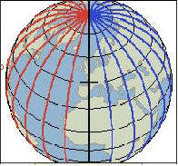 |
The black concentric circles running horizontally are the lines of latitude which run from 0 degrees at the equator to 90 degrees north at the North Pole and 90 degrees south at the South Pole. |
The best way to remember which is which is to remember the Jimmy Buffett song Changes in Latitude which is about heading south to warmer climates. So latitude is degrees north or south of the equator. The United States is usually referred to as the west while Japan is the far east. That is because the US lies in the western hemisphere (red lines) while Japan on the other side of the international date line lies in the eastern hemisphere (blue lines)

![]()
Are you afraid of pirates?
A. Actual cases of piracy are quite rare in the Caribbean. But in Asia and the mid east it is a huge problem. Professional pirates in the South China Sea attack large freighters full of Japanese TV's and stereos. In the Gulf of Aden the Somali pirates are very bold and very successful having captured dozens and dozens of oil tankers and freighters for ransom. The biggest security issues for sailors in the Caribbean usually involves thieves sneaking up to the boat at night and trying to steal the outboard motor from the dinghy. We generally lift our dinghy out of the water at night and also lock it wherever we go. In 2009 we transited the Gulf of Aden which was having more than one pirate attack per week. To read about a pirate attack there click here.
![]()
What is the worst storm you have been in ?
As of 2009 we can report that we have only been in two bad storms at sea on Ventana. Fortunately our first experience in a bad storm was earlier when we were crew on an 80' boat with a professional captain and several professional sailors. Usually we just make the boat as safe as possible and try to hang on until it gets better. At anchor we have sat out quite a few storms with 40-50 knot winds and one hurricane with winds to 90 knots. To read about the hurricane click here. To read about storms at sea click here- Pacific Storm or here- Indian Ocean Storm
Back to Top
![]()
Do you get seasick?
It is not uncommon for us to feel a bit lethargic on rough passages. This usually manifests itself as simply feeling any movement is too much effort. Rob has on a very few occasions lost his lunch after spending time in the cabin below to work on navigation. Dee gets lethargic but fortunately seems to be quite immune to any real seasickness.
Back to Top
![]()
How do you get mail and stay in touch?
We use a mail forwarding service to collect our mail. Once every month or two (or three) we let them know where we will be and they send us a large package with all the mail from the last 2-3 months. We also have daily email on-board Ventana through our ham radio. To get in touch with us click here. To read more about communications click here.
Back to Top
![]()
What do you do all day?
This is surely the funniest question we get asked - and often. No, we are not sipping Pina Coladas on a beach all day. A good part of every day is spent taking care of the boat. Then depending where we are we may be snorkeling, fishing with spear guns for dinner or experiencing what there is to see and do ashore.
What is hard to understand is how long simple things take in a third world country where you have no car or phone. Doing the laundry can be a half day project. Making a simple phone call takes an hour. Needing a small part for the boat can require most of a day with a dinghy ride to shore, bus to town, walk around to 3-4 places hoping to find what you need then dealing with the language barrier to get the part before doing it all in reverse to get home. With the high heat and humidity by then you are too wilted to install the part.
Back to Top
![]()
How do you get along in such a small space?
For some couples this is a bigger challenge than others. While the boat space itself is small our home is really the entire anchorage. Dee spends every free moment on deck in the cockpit where she has a 360 degree view of a beautiful and interesting new spot every week or two.
For us having worked side by side in business for 20 years the transition to the boat was easy. We long ago figured out how to quickly work out our differences and move on. We love doing everything together and always having our best friend nearby to share experiences.
Back to Top
![]()
What is your favorite place so far?
Picking a favorite spot is nearly impossible. A few places that have been most special for us are the Island of Tobago, Glovers Reef Belize and The Grenadines. You can read about them in our logs.
Back to Top
![]()
What do you miss the most?
For Dee the answer would be her garden and having a dog. A black lab to be specific. For Rob it is flying small planes, skiing and kayaking. Both of us miss family and friends and encourage visits.
Back to Top
![]()
What do you like the best?
Dee- The freedom, the ability to be mobile and to move my home. The compactness and organization of our boat. Traveling with my best pal. The infinite variety of places and people.
Rob- Every day is different and you never know what tomorrow will bring. The freedom to move about. Seeing new places. Learning how to repair and maintain everything on the boat so we can be self-sufficient. Scuba diving and snorkeling. Sharing adventures with Dee.
Back to Top
![]()
Do many people do what you do?
The cruising community is quite large and growing all the time. Rough estimates of cruising boats in the Caribbean basin might be 8,000. Cruisers fall into 3 broad age groups. Those who worked hard, put the kids through college then retired at age 65 to go cruising. Those like us in the 30-50 age range who had successful careers, took some sort of early retirement and went sailing. Some of this group are only out for 2-5 years then plan to return to the workforce. There are also many families in this category and in most anchorages it is common to see families with children 5-15 years old being home schooled. (We invariably find these kids light years ahead of their shore based peers in all areas of their education and socialization). The last group and by far smallest number are those under 30 who are taking a few years off between college and work. They tend to be on smaller boats, doing things on a shoestring , but always inspire us with their inventiveness and gypsy attitude.