


A new navigation tool we installed in Ventana in 2009 has proven to be a fantastic addition for offshore passage making. The system is called AIS and it is similar to the transponder on all airplanes that allows air traffic controllers to see where the planes are. All large vessels are required to carry AIS transmitters and broadcast their position continuously. They also have built in receivers allowing them to see each other so they can avoid collisions. The broadcasts use the same airwave frequency as our VHF communication radios.
On Ventana we have only a less expensive receiver- so we can see the big ships but they cannot see us. The AIS system on Ventana is by Vesper marine and consists of three different black boxes. First is an antenna splitter that splits the signal from the VHF antenna and sends it out to both our VHF radio and to the AIS receiver. Next is a box that is the AIS receiver itself which processes the signals and last is a display with a monochrome LCD screen that looks like a radar display. The display allows us to see the location of all the large ships anywhere near us, greatly simplifying our night watches.
Without AIS the person on watch stands up every 20 minutes and checks the radar then scans the horizon for 360 degrees. If you see a ship's s lights you then have to get out the binoculars and try to pick out the colored navigation lights so you can determine which direction the ship is going. Next you take a compass bearing on the ship and watch for 5-10 minutes to see the bearing change and how much it is changing. This tells you if you are on a collision course. Often we just alter course anyway because you cannot tell exactly how far away you will be and you do not want to be anywhere near a ship 50 times your size that can run you down without even noticing it. Changing course often involves adjusting sails, tacking or jibing and in general is lots of headache. Plus you never really relax until you have finally crossed paths with the ship.
With the AIS system you get a text and graphic readout of all the shipping near you and you know their exact course and distance from you and most importantly it tells you the closest point of approach or CPA. If the CPA is a mile or more away you are probably fine and do not need to do anything. If it is less than that you might want more room and the AIS immediately tells you which direction is best for you to alter course. It also tells you how long until your paths cross.
In very good visibility you can see a ship 7 miles away. Many of the newer ships have speeds up to 25 knots and without AIS it could only be 15 minutes from when they first are visible to when they could potentially run you down. And that is if you happened to see them at the exact moment they came within view. If visibility is bad or it's raining you will have less warning and even if you run your power hungry radar it cannot see through rain. With the AIS we see ships as far away as 100 miles or more. We have ours tuned to warn us of any within a 24 mile range and this allows us to take action to avoid them much earlier than if we waited until we saw them. Since we know exactly how close we will come to them we usually do not have to do anything whereas previously we would alter course just to be sure. For the ships that are on a true collision course we see them so far in advance that rather than a big course change which requires adjusting sails now we usually can just adjust the autopilot a few degrees which will keep us clear and not require moving sails. Then when the ship does come over the horizon into view we just take a quick glance to confirm what the AIS is telling us and there is none of the usual anxiety of waiting to pass clear of them.
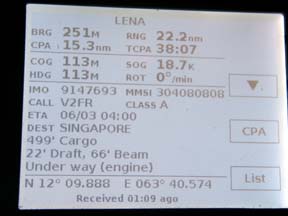
The display unit gives us a radar like picture of where we are in relation to each ship and also where we will be in relation to them at the time of CPA. Also it gives us a text readout of all the pertinent information about their course, speed, MMSI number etc. It's great fun reading about the ships details and where they are headed. Our favorite was a super tanker headed for the Gulf-she was 1,200 feet long, 187 feet wide with a draft of 65 feet and going 25.3 knots!
Before AIS we might call a big ship on the radio to confirm that they have seen us and will not hit us but since we can only say "big ship near latitude such and such" they they rarely answer. Now with the AIS we have the name of the ship and so when we call them by name they readily answer. If you have a newer VHF radio with an MMSI number you can call them via that and it rings on their bridge just like a telephone and they must answer.
Big ship traffic from Malaysia across the Indian Ocean to the Red Sea and Suez canal is the heaviest continuous concentration we have seen anywhere in the world and now I cannot imagine doing this passage or any other without AIS. I rate AIS as nearly as big a breakthrough as GPS for safety at sea.
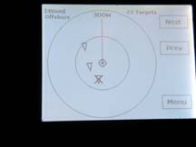
Radar type display shows targets
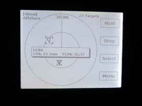
Any target can be highlighted
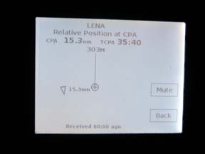
The position at CPA can be displayed
and their headings
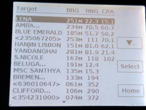
The text list tells you about all the targets within 50-100 miles
Any individual boat's details can be seen