


Below is the text and handout from a speech on weather that Rob last gave at the West Coast Florida Island Packet rendezvous in 2000.
Handouts
Weather Basics
Points to Remember
1. Hot Air Rises
2. Nature Abhors a Vacuum
3. Air flows out from a High Pressure Area
4. Closer Isobars mean Stronger Winds
5. In the Northern Hemisphere air exits a high going clockwise and enters a low moving counterclockwise.
Internet Sites
Weather fax Products
http://205.156.54.206/om/marine/home.htm
Surface Maps http://www.hpc.ncep.noaa.gov
Satellite Images http://www.goes.noaa.gov
Upper Air & Satellite Charts http://weather.unisys.com
Caribbean Weather Caribwx.com
Intetticast Intellicast.com
Marine Weather
http://www.marineweather.com
Sailnet http://www.sailnet.com
SSB Voice Weather Broadcasts and Weatherfaxes
Time UTC Product Frequency
0000,0600, 1200,1800 Weatherfax 4316, 8502, 12788 USB
Broadcast from Bell Chase, LA 4 times per day
Included are US & Tropical Surface Analyses, Wind & Wave forecasts, Text forecasts,
and a Satellite Picture.
Time UTC Product Frequency
0330,0930,1600,2200 UTC NMN Voice Wx 4426, 6501, 8764 USB
1100 UTC Caribbean Maritime
Mobile Ham Net
7241 LSB
1130 UTC Caribbean Mobile Ham Net- Wefax 7086 LSB
1230 UTC Caribbean Wx Net -- David 4009 USB
1300 UTC Caribbean Wx Net --David 8104 USB
2000 UTC Southbouind 11 -- Herb 12359 USB
Speech:
Hi I'm Rob Dubin I want to thank Ian and Liz and their crew for
putting on another great rendezvous. I also want to congratulate everyone at
Island Yachting Center because they again were given the award for the best IP dealer in the country by their customers. Let's give them a hand.
My wife & I bought our IP 40 from Ian in 1995 and for the last 5 years we have lived aboard and cruised full time. We've been north to Maine and through the Bahamas, and the Caribbean basin to South America, Central America and Mexico. What we would like to do today is spend some time talking about weather and then move on to a general question and answer session about anything to do with cruising.
When we started cruising in the Bahamas something that really surprised me was how many hours a day we and everyone spent on the weather. We would get 2-3 daily weather reports, study them then rehash them with all the nearby boats. Instead of gong out snorkeling we'd spend 1/2 the day deciding if the weather was OK for snorkeling. The other thing that surprised me was how much uncertainty and confusion people still had about the weather despite all the information available..
If you don't understand the weather you will never be comfortable cruising on our own. What we saw a lot of in the Bahamas was group cruising. Inevitably one person who understands the weather or maybe who just likes to be in charge takes it upon himself to be the weather guy and everyone blindly goes where and when he says. And as often as not people got into trouble doing this.
Weather forecasting is of course not always accurate, but forecasts looking only a day or two ahead are generally pretty good. And since the islands in the Bahamas and Caribbean are so close together it is possible to cruise the entire
Caribbean basin with only a very few overnight passages. This makes it feasible to cruise the entire Caribbean with little or no bad weather and that's what we did.
Of course we first spent thousands of dollars outfitting our boat with heavy weather gear-- we have sea anchors and
drogues and storm sails and all that stuff but the bottom line is by picking good weather windows and being patient enough to wait for the weather to change we have never used any of it and rarely had any bad passages.
So my advice is to learn about the weather so you can pick your own weather windows and to be patient when you need to wait for a change in the weather. If I were to give new cruisers one bit of advice it would be WAIT FOR
WEATHER WINDOWS. My wife is fond of saying "The only weather you can control is the weather you leave port in."
In most weather discussions people often glaze over after about 5 minutes when the brain goes into overload. That's not going to happen today. First of all I'm not a
meteorologist and I am not even very smart so I don't know enough to make it complicated.
Understanding the basics of weather are really quite simple. In fact I am sure most of you will be familiar with everything I say today but hopefully we can tie it all together in a way that will be helpful to you in the future.
If you can just remember 5 simple points you can understand most of what happens with weather.
There are really only2 causes of weather So these are the first 2 points to remember.
1. Hot air rises
2. Nature does not like a vacuum.
If you understand these two things all weather will make sense to you.
All weather is simply movement of air based on these two actions. Now since we can not see air I am going to use the analogy of water which we can see.
Also thinking of this water analogy will help you remember these tips in
the future.
OK lets look at number
1. Hot air rises-- to help remember this think of our water analogy --hot water is steam and of course if you think about a boiling pot of water the hot steam rises.
Number 2. Nature abhors a vacuum. What is a vacuum-- a vacuum is an area of lower pressure. When a parcel of warm air rises it creates a partial
vacuum so nature sees to it that other air is going to rush in to take its place.
This happens on a grand scale with warm air near the equator rising and colder air coming down from the poles to fill the space vacated by the warm air. It happens on a smaller scale all along the coast every afternoon with an afternoon sea breeze.
Has anyone here ever sailed on SF Bay? Hands? What happens each afternoon in the summer?
(It blows about 30 knots). Exactly.
What happens is the Sacramento valley just inland from SF heats up-- the hot air
over the valley rises forming a partial vacuum. What happens next? Cooler air from out over the ocean gets sucked into the
vacuum -- and since SF has a great big bay with the peninsulas of land closing it in you get a
venturri effect and the air really gets sucked in hard right past the golden gate bridge. So that is points
1 and 2 in action. Now I don't have a water analogy for this so just remember sailing in San Francisco sucks.
Ok as we move on remember these two points because all weather is caused by this interaction we just discussed. Hot air rising and cooler air coming in to fill the
vacuum. Any questions so far? OK Feel free to ask questions at any time.
Weather maps and highs and lows
We have all seen weather maps on TV and in the newspaper so lets look at how to understand a weather map. And here we are going to use another analogy.
Before I was a sailor I was a mountain climber. As a mountain climber you use topographic maps. Who here is familiar with
topographic or topo maps? Good?
If you are not familiar with a topo map they tell you the elevation of all the terrain, so as a climber I can look at the map and see one section is a cliff face and another section might be a smooth slope right to the top.
A topo map has a different line to represent each level of elevation.
Every point on a line is the same elevation.
Section of a topographic map showing Pikes Peak
Colorado. This topo shows a steep cliff with
elevations from 12,000 feet to 13,400 feet.
Each line is 40 feet apart and they are labeled
each 200 feet. If this was a flat meadow the lines
would be very far apart.
.GIF)
Does everybody know Mt. Fuji in Japan -- its the perfect volcanic cone. From the ground it looks like
an inverted V and on a topo it would look like concentric circles. . Does that make sense to everyone?
Now a crater in the earth would also look like concentric circles so we need to look at the numbers next to the lines to see if it is going up or down toward the center.
Any questions so far?
I was recently at Niagara falls -- Now you can imagine what Niagara falls looks
like on the topo map. The lines are so close together they are on top of
each other. In fact they just print one dark line and label the height of
the falls, but you would get the idea that it is a cliff and if you looked at the numbers
you might see one at 500 feet elevation above sea level and this one here
at 300 feet above sea level so you know this is the bottom of the cliff and this
is the top and the falls are 200' tall.
What does all this have to do with weather? If you look at the weather chart
below you will see it looks
similar to a topo map.
Just as a topo map shows lines of equal altitude a weather map shows lines of
equal barometric pressure. These lines on the weather map are called isobars. So
just as every point on one line of the topo above represents 12,000'
every point on one isobar line in northern Florida represents 1024 millibars of pressure.
Just as Mt. Fuji has concentric circles indicating
its elevations you can see the concentric circles
surrounding the High pressures over New England
and Bermuda
click to enlarge
So this map is telling us that the center of this Atlantic high pressure area is
1028 millibars and the
pressure is less as you get farther away from the top of the high. It is just like Mt. Fuji
where the altitude is less as you get farther away from the high summit.
Now we come to our 3rd point to remember.
No. 3. Air descends outward from a high pressure area To help remember this think about our water analogy- water runs downhill from a high mountain to the low land below.
Now lets look at Niagara falls on top the lines are fairly far apart - that means the land is fairly flat-- what do you imagine the river
will do here.-- Right it flows slowly and smoothly. Now what happens when it gets here where the lines are close together. Niagara falls is what happens- the water
plummets at great speed to get to the bottom. Then here where the lines are far apart it flows slowly again..
OK -- make sense to everyone -- its the 4th thing you need to remember
If the lines are close together like the water in Niagara falls
it will move very fast. if the lines are far apart its like a slow moving river. Since the water in our analogy represents air that means:
4. If the isobar lines are close together you'll have strong winds if they are far apart you will have gentle breezes.
Now we have Mt Fuji and we have a crater next to it. We know this is a crater because we see the numbers are lower toward the center. Mt. Fuji is very high so lets call it a High and put an H here. The crater is very low so lets put an L here. We remember that air behaves like water so what's going to happen if we pour a gallon of water on top of Mt. Fuji? Point 3 happens. It runs downhill or out and away from the high.
If this were a weather chart like the one above the air which we call wind is going to flow outward from the high to the low-- just like the water does. Now the wind should just run straight from the high to the low but because the earth is spinning it creates an effect like this .
(arrow going clockwise out from center)
So that's the 5th thing you need to remember.
5. In the northern hemisphere air
leaving a high goes clockwise and air entering a low goes counterclockwise.
You can remember this because we all know the water goes out the bathtub drain
counterclockwise in the northern hemisphere.
So lets look at the weather chart handout. We can see highs and lows and ridges and troughs. A ridge is just like a mountain ridge. It is a high but instead of being shaped like Mt. Fuji it is elongated. A trough is a valley -- it is a low pressure area that has not
developed a circular rotation. Highs do not have any frontal systems associated with them but lows are associated with the mixing of cold and warm air or cold and warm fronts. During summer in the Caribbean tropical waves or trofs move from Africa to the Americas with a new one
coming every 3-4 days. When the conditions are right these trofs are what form into tropical weather systems and can eventually form
hurricanes
On weather charts a trof is indicated by a dashed line and a ridge by a zig zag
line.
Fronts
This is the symbol for a warm front. (See
warm front over middle US on chart above). This is the symbol for a cold front.
(See mid Atlantic cold front on chart above). I remember it as a cold
front is more hard edged just as a triangle is more hard edged than a semi
circle When a front stops moving it is called a stationary front and it looks
like this (line with semi-circles on one side and triangles on the other side). I remember it as it can't figure out which way to go The last type is an occluded front and it's shown like this
(alternating triangles and semi circles on the same side).
I know everyone is familiar with cold and warm fronts but let's define them a bit more. A front is a parcel of advancing air. If the advancing air is colder than the air it replaces it is called a cold front. If the advancing air is warmer it is called a warm front,
Now what was the first point of the of the 5 points we're going to remember.
Hot air rises So in a warm front the warm air is moving and since hot air rises the warm air is going to push over the top of the cold air like this.
In a cold front it is the cold air that is moving and it will force itself under the warm air. Because cold air moves faster a cold front will approach rapidly, bring quite stormy conditions and move on
quickly
A warm front will approach more slowly, be less violent and may hang around for longer.
Forecasting
Often on a synoptic weather chart like the one above you will see a classic low pressure system with associated warm and cold fronts. It starts as a trof then it begins to circulate. It looks like this.
(handout)
Often a cold front will overtake the warm front and become occluded then the system will usually
dissipate.
Now as fronts approach you hit you and move on each phase is accompanied. by predictable patterns of clouds and predictable changes in wind speed and direction and
predictable changes in temperature and barometric pressure.
So if you have been attentive to what happened yesterday to you its is fairly easy to predict today and tomorrow. For instance if a warm front is approaching and you've seen the clouds lower for two days and if the barometer
drops and the wind shifts from NE to SE, you can predict that tomorrow you'll have S or SW winds and the day after the wind will keep clocking around to the W and eventually NW as the front moves off. And
because you can keep track of these things right where you are you can be knowledgeable and make your own predictions.
How many boats here have a barometer on board How often do you look at it and record it.
You probably know that a barometer reading by itself is almost meaningless-You might think high pressure means good weather and low pressure bad
weather. Well in the Caribbean a high is bad news because it means much stronger winds. The pressure is high the isobars are close together so you get stronger winds.
What is important to watch. on your barometer is the rate of change in pressure--how much it drops in how many hours. If it drops more than 6 millibars in 6 hours get ready for a blow.
I suggest you get a recording barometer and if you can get a recording thermometer. That way you can see the changes and really forecast the weather.
Here is a new one I bought for Ventana recently.
Another tool I suggest you keep on board is one of these Davis Weather cards. There is a huge amount of useful information on these little cards. They explain fronts and help you recognize cloud types and help you use your barometer and thermometer and winds to predict weather for the patch of ocean you happen to be in. If done well you can predict weather for yourself more accurately than a
forecaster miles away on shore somewhere.
Ok we are just going to cover a few more things then move on to a general Q&A.
Internet Weather
The internet has unlimited sources of weather information and I have listed some of them on your handout sheet. When we are off cruising we can get internet access from most islands but when we get offshore we get our weather from about 4 different sources. First is voice weather broadcasts. On your VHF radio you can receive the USCG At sea on your Single SideBand radio you can get voice weather broadcasts from local stations in the Bahamas and Caribbean and from the Coast Guard via HF stations such as NMN. Some people also get specific customized weather routng instructions this way.
If you have weatherfax capability using your SSB and computer you can get about 5 different products broadcast daily from the Tropical Prediction Center.- and we will look at those in a minute.
If you have ham radio ability and a computer set-up you can get your email and at the same time receive additional weather products off the internet through your ham radio gateway. I am not sure but I think some
commercial services are now offering a similar set up for non hams.
If you add a special helical antenna about this big (2' tall by 8" Dia.) you can also receive real time satellite broadcasts direct from polar orbiting
satellites so you can see visible cloud Pictures and infrared cloud pictures.
Lastly if you have a phone hookup onboard you can access the internet.
Since weatherfax is the most common lets take a look at the products you can receive via weatherfax.
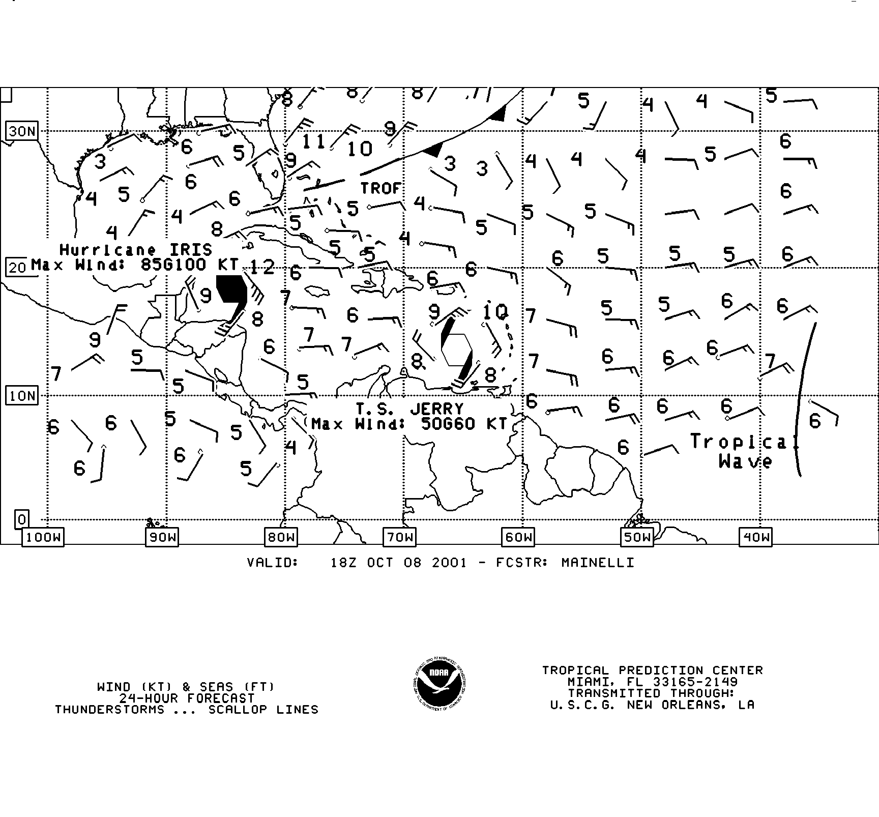
4 times per day the US government broadcasts weather fax products and each time the info is 6 hours newer. The Products they send are the US & Tropical surface analysis. This is the type of synoptic weather chart we discussed earlier.
(See above chart). They do one for the US and one for the tropics. They also send a wind and wave forecast. And for
sailors making mostly day hops in the Bahamas and Caribbean these are the most important products.
 Click
the graphic to enlarge it and you will see
Click
the graphic to enlarge it and you will see
it shows the three key pieces of information you are most interested in. How much wind will I have?
From what direction will it come?
How big will the seas be? It is easy to read.
The arrow indicates the direction of the wind,
there is one barb for 10 knots or one and a half barbs for 15 knots. 50 knots is a flag.
The numbers are the height of the seas.
They transmit 4 wind and wave forecasts.. One is current conditions and they
also send 24, 48 and 72 hour forecasts
You can also get a satellite picture that looks like what you see on TV.
And lastly they send a text version of the voice broadcast. The difficulty with
the voice and text forecast is that it covers a very large area and so is not
very detailed. One caveat with these weather faxes is that they are usually
prepared by several different people and sometimes the forecasts will be a bit different.
If you get on the internet there is one other chart that is handy for forecasting and that is a 500 mb chart. It basically looks like the surface charts we talked so much about earlier, but it shows the isobars at the jet stream level and it is helpful for making predictions.
So to wrap it all up I think if you remember the 5 points we mentioned here today and learn. to identify clouds and use your barometer you can become your own weatherman and get quite good at it
Most importantly -- pick your weather windows carefully and you are likely to have safe and comfortable passages.
Any Questions.
My wife is going to join me now for any other cruising questions you might have.
Thanks.